Wednesday, July 31, 2013

Planning Ahead and Hiking Purple Mountain in Yellowstone NP

Island Park, ID                          (Click on Pictures to Enlarge)

A large part of our past few days has been spent deciding which direction to head after leaving this area and making reservations which will ensure us that we have a campsite over the coming Labor Day Holiday.  We've found that places aren't usually too hard to get into unless a holiday is involved.

Our plans are pretty flexible at this point.  So flexible in fact that we had no idea which direction we would be heading after we leave here next Monday.  We initially thought about heading down to Utah to visit several of the parks and sights in that area, but thought that the temperatures might still be a bit too hot for us at this time of the year.

Then we thought about heading over to Washington State and visiting the Pacific Northwest area.  We've loosely decided to head west to Oregon and bounce over to the coast before starting a slow movement toward Arizona for the winter months of Nov, Dec, and Jan.

Our plans are solidified at this point until September 18th. 

Enough thinking for now. It's time to get back to the fun.  Today we went back into the western part of Yellowstone (near the Madison area) and took a hike up to the peak of Purple Mountain.  The Purple Mountain climb is about 6 miles roundtrip and climbs 1500 feet to near 8500 feet.  The hike to the peak is almost a constant ascent, not many level runs, but was a lot of fun.

As is typically the case, the views from the top are certainly worth the climb. Here's a panoramic view of the Firehole Valley and lower Gibbon Valley.

It was pretty windy at the top, and chilly as well. Sorry, the camera moved a bit on us and we lost our feet!

Walking a bit over toward the southern side of the peak you can see the Madison River in the valley below.

Karen taking a moment to grab a snack after the "obligatory" pictures at the top.

Although the skies were clear and a pretty blue when we began the hike at the base, we had read that this area is prone to weather changes during afternoons in the summer.  Today was no exception.  Thunder started to rumble and the skies were getting dark.  Time to start the descent.

We had descended about a mile when it began raining on us.  We had jackets, but the final two miles were still not as fun as it could have been.  We did make the climb down a lot faster than the climb up, however!

Again, thanks for dropping by to take a look!

Saturday, July 27, 2013

Mesa Falls Scenic Byway and Big Springs Area

Island Park, ID (Click on Pictures to Enlarge)

We decided to take a break from Yellowstone NP yesterday and explore some of the attractions near us. We learned something new about the "City" of Island Park as well. We had been somewhat confused since arriving here as we saw a roadside sign indicating the beginning of the city's limits just after getting into Idaho, but were confused as most maps show Island Park many miles further south on US20.

From the official City of Island Park's government website:

The City of Island Park, for all other descriptive words, is "unique" in it's (sic) entirety. It was incorporated May 16, 1947, to meet a state law requiring businesses that serve or sell alcoholic beverages to be within incorporated towns. The City's government at the time drew up the City's boundaries to include all the businesses from the Last Chance area north to the Montana border that desired licenses to serve and sell alcoholic beverages. All other areas of what is now known as the Island Park Recreational area remains in Fremont County. .... Since 36.8 miles of Highway 20 are in the City, the City of Island Park proudly boasts that it has the "Longest Main Street in America".
We read about an area called Big Springs in some local literature. Since it was only a short drive south of us we decided to take a drive.  Big Springs, by some accounts, is the 40th largest spring in the U.S. Its' waters are derived from the Yellowstone Plateau and flow into Henry's Fork of the Snake River.   

Big Springs flows 120 million gallons of water per day at a year-round constant temperature of 52 degrees.

The water here is crystal clear and is said to support some of the best trout fishing in the country, although fishing is prohibited near the springs. In fact, all types of boating, fishing, and swimming are prohibited until about a mile downstream near an abandoned railroad trestle. The only activity allowed here is the "feeding" of the fish and seagulls.

There is a 1-mile nature hike which parallels Henry's Fork from the Big Springs area down to the railroad trestle. This is a favorite wildlife viewing area for moose, elk, possibly bear, and lots of birds.

An interesting structure built right beside the springs is Johnnny Sack's Cabin. Johnny Sack was of German descent who leased a tract of land from the US Forest Service in 1929 and shortly thereafter built this cabin and a small pump house using only hand tools and with only little assistance.  He was the lone winter resident in the entire area.


After completing our short nature trail walk we jumped back in the car to again head approximately 6 miles south of Island Park (the spot on the map) where we picked up the Mesa Falls Scenic Byway. The route is 28.7 miles and begins at FS294 in the north and ends in the town of Ashton (at US20) to the south. It generally follows Henry's Fork of the Snake River along the drive.

The main attractions on this drive, aside from the landscape along the road itself, are the Upper and Lower Mesa Falls.

The Upper Mesa Falls is the largest and usually draws the largest crowds, although there were very few present today.

The viewing area decks enable folks to get very close to the falls. It's hard to see in this picture, but the constant mist created by the falls, which sprays onto the opposing canyon wall, forms a microclime which enables  very lush, green vegetation to survive year round.

At the top of the trail area is today a Visitor Center, but it originally housed Big Falls Inn. The structure was built in 1915, but has served many purposes throughout the years.


A couple of miles furthe down the Mesa Falls Byway you come to the Lower Mesa Falls.  The observation point for this falls is far up the hill, thus this falls doesn't have the same visitor impact as the Upper Falls, but it's still pretty to view.

The Byway ends in a few miles at Ashton after traveling through some huge open farming areas. A short, easier sightseeing day was a welcome change. 

Thanks for dropping by to take a look!

Thursday, July 25, 2013

Canyon Area of Yellowstone National Park

Island Park, ID                                 (Click on Pictures to Enlarge)


Map Courtesy of NPS
            The above map shows our travels for Wednesday 7/24/13.

Our intention was to travel from the Canyon Village area to the West Thumb area.  This is the remaining section of the "figure 8" we had yet to complete.   Well, you know how fulltimer's plans change.....and they did again today.

We had already explored the area known as the "Grand Canyon of the Yellowstone" on a previous trip by making stops along the south rim.

Today we started our trek along the north rim.  After exploring both sides, let me advise folks who are limited in time, please make it to the north rim.  Although both rims are beautiful in different ways, the north rim enables you to see some beautiful views. This is one of my favorite pictures taken from the area called "Brink of the Lower Falls" looking east.

Crowds at the edge of the Lower Falls
We started here and climbed down a very steep switchback trail to get a closer look at the Lower Falls.

The water flowing over the falls is very clear and the Lower Falls flows approximately 109 feet to the bottom.

Moving along the north rim we came to a place named Lookout Point. Truly nice views of the Lower Falls from this high position.

Closer View of Lower Falls
From Lookout Point we decided to take an even steeper trail down to Red Rock Point. This trail dropped 500 feet in 1/8 mile.  Needless to say, the trail isn't bad going down (unless you have bad knees), but I will admit to stopping several times on the way back up.

Here's Karen as we start back up the trail.  Yes, she still looks pretty rested at this point. That's Lookout Point at the very top of the rocks.

The next stop is called Grand View and is very aptly named.  This is one of those "pictures don't do it justice" moments.  You can see the Lower Falls looking west or the canyon walls looking east. The colors are beautiful!

Our last stop in the Canyon Area was at Inspiration Point. More great views.


From the Canyon Area trails we headed south toward Lake Village and Bridge Bay.  Between these points you pass through the Hayden Valley, home to many species of wildlife in Yellowstone Park. It was now about 4:30 PM and time for the wildlife to start doing their "evening" show.  I guess the word didn't get to any except the bison today, because they were the main drawn.  It literally took about 30 minutes to go about 3 miles.  This is not a complaint, just a warning to anyone traveling through this area of the park during this time of day.

Two calves beside the road
The bisons were everywhere today.  Both sides of the road, crossing the road (which brings the Rangers to the area to assist) and actually running up some of the hills.  What's a blog about Yellowstone without a couple of bison pictures.

Then there was "Big Boy" standing watch beside the road as well.


We finally made it down to West Thumb by late afternoon, but there wasn't nearly as much to see along the way, so we decided to call it a day. We've now traveled all of the main roads in Yellowstone (it only took us 5 trips!) and we're ready to branch out.

Stayed tuned for some hiking and hopefully a boat tour of the Yellowstone Lake in the coming days.

Thanks again for stopping by!

Tuesday, July 23, 2013

The Northern Part of Yellowstone Park- Mammoth Hot Springs to Lamar Valley

Island Park, ID          (Click on Pictures to Enlarge)

Map Courtesy of Yellowstone NPS Website


On Monday (7/22/13) we returned to Yellowstone Park to venture into the northern areas of the park.

Our first pullout was an area called Golden Gate Canyon. This area was named for the golden look of the cliffs above the river below.  Today's asphalted bridge was originally a dirt stagecoach road built above wooden posts. At one time a tunnel was cut through the side of the mountain near today's bridge, but it collapsed and was abandoned in 1933.  Today's bridge was completed in 1977.

The main natural attraction in the Mammoth Hot Springs area is the Mammoth Hot Springs Terrace located above the "touristy" area. We actually missed the sign to the Upper Terrace Drive and turned around.  Sure glad that we did.  The geysers in this area are fewer than other areas of the park, but the springs other features are very large.
Upper(L): Hot Springs Terrace   Upper(R): Name Unknown
Lower(L): Mound Terrace  Lower(R): Palette Spring


Traveling further down the hill we came to Mammoth Hot Springs. Two prominent complexes here are the Albright Visitor's Center and the Mammoth Hot Springs Hotel. We didn't spend much time here as we wanted to push on toward the Lamar Valley today and see some wildlife.

On the way east toward Tower-Roosevelt we came upon a 6-mile dirt (and very bumpy) road named Blacktail Plateau Drive.  I thought this might be a good drive to view some wildlife. Wrong!  We saw nothing. Other than dust from other vehicles.

Actually, we stopped at some very nice pullouts with views of the surrounding valleys and mountain ranges to the north.

When we reached Tower-Roosevelt we turned north toward the Lamar Valley which eventually takes you to the northeast entrance of the park. We ate lunch at a nice picnic area near the Yellowstone River.

We are driving up to the Lamar Valley because this is supposed to be a "prime" area for viewing all types of wildlife which are present in the park.  Because we were in this area in the middle of the day, chances are much less than early morning or late evening of seeing a lot of wildlife. The old standby, the bison, can always be counted on!  We saw this one by himself on the side of the road.

We did see a few elk, several pronghorn antelope, but again, many bison.  This picture only shows about 1/20 of the herd we saw in the valley today.

We returned to the Tower-Roosevelt area and began our trip home towar Canyon Village. Pretty tired today (and we didn't even do any real hiking!)  There is a fair amount of road construction in this area and waits of 20 minutes are not uncommon.  We finally got through the slow areas and took a picture of the valley near Dunraven Pass.  The sign indicated that grizzly bears are common in this area, but we have not seen any in the entire park yet.

That's about it for today's park exploration.

Thanks for stopping by to take a look!


Sunday, July 21, 2013

Yellowstone's Old Faithful Area and the Norris Geyser Basin

Island Park, ID                                    (Click on Pictures to Enlarge)


(Map Courtesy of NPS)
                      The map of today's travels in Yellowstone NP

Visitor Center and Education Center
In our last blog I mentioned that we attempted to see Old Faithful Geyser at the Old Faithful Visitor and Educational Center, but the crowds were just too much.  I couldn't even find a place to park in the lot.

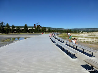
Viewing Area in Front of Old Faithful Geyser
Today we decided to make Old Faithful the first stop on our list of sights to see. Hey, what happened to the crowds? Actually, this picture was taken about 15 minutes after the famous geyser had erupted.

Times for the next expected eruption are posted at the Visitor's Center. The geyser is currently erupting about every 90 minutes +/- 10 minutes. The next slated eruption is set to occur at 12:02 PM.

With everyone in their seats and a large crowd assembled around the perimeter of the viewing area, the Old Faithful Geyser started erupting right at 12:05 PM. (pretty consistent, I think)


We initially thought we'd only watch Old Faithful and move on to our next destination, but once we looked at the trails and attractions map for this area, we knew that we would be here for a bit.

There are many, many geysers, pools, and other hydrothermal features to see around the park, and a WHOLE bunch in this area. I spare you from looking at too many of these and just post a collage of a few in this area.
Top(L): Doublet Pool   Top(R): Wave Spring
Lower (L): Chromatic Pool  Lower(R): Castle Geyser
I will single out one geyser named Giant Geyser. It became dormant in 1955, but in 2007 it erupted more than 50 times.  For many of the major geysers the NPS will post their expected eruption times and dates. We decided that we just couldn't wait around for the next eruption of Giant Geyser since the last one was in 2010.

Firehole Spring
After leaving the Old Faithful area we headed north and ate lunch at one of the many roadside picnic areas.  Just north of our lunch spot we took a side trip down Firehole Lake Drive.

Our next destination is the Norris Geyser Basin. On the way there, we stopped at Gibbon Falls to take a few quick pictures.  We saw a hawk traversing the canyon, but never got a picture. I guess a picture of me with the Falls in the background will have to suffice.

I will have to tell you that a long day visiting Yellowstone Park will tire you out. (Well, at least it tires us out!) We wanted to get to Norris Geyser Basin by the end of the day and I'm glad we did. This is a very different area from many we've visited so far.

As we walked down the boardwalk to begin our tour of this area some other folks told us that we had just missed seeing a very large bison walking through the area. We caught a brief glimpse of him as he was heading into the treeline to our left.
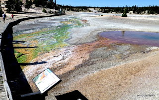
Whirligig Geyser
The area presents a varied array of features.  We love the many different colors created when thermophiles (heat-loving microorganisms) occupy the water in different areas as the water cools along the edges and channels.

Steamboat Geyser
The Norris Geyser Basin is a bit special in that it has the highest ground temperatures found in the park. It also contains Steamboat Gyser, the tallest spouting geyser in the world. It throws a spray 300 feet into the air.  The catch is, it doesn't erupt in any predicable intervals.  When it does, however, the eruptions last anywhere from 3-40 minutes.

By now, we were tired and ready to call it a day!

Thanks for stopping by to take a look.